


Maxwelton 1 Voting District, Island County, Washington
About
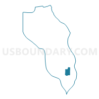
Outline

Summary
| Unique Area Identifier | 684440 |
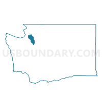
| Name | Maxwelton 1 Voting District |
| County | Island County |
| State | Washington |
| Area (square miles) | 6.08 |
| Land Area (square miles) | 6.06 |
| Water Area (square miles) | 0.01 |
| % of Land Area | 99.78 |
| % of Water Area | 0.22 |
| Latitude of the Internal Point | 47.97446510 |
| Longtitude of the Internal Point | -122.41044110 |
Maps

Graphs
Select a template below for downloading or customizing gragh for Maxwelton 1 Voting District, Island County, Washington


Neighbors
Neighoring Voting District (by Name) Neighboring Voting District on the Map
- Coles Voting District, Island County, WA
- Deer Lake Voting District, Island County, WA
- Glendale Voting District, Island County, WA
- Maxwelton 2 Voting District, Island County, WA
- Sandy Point Voting District, Island County, WA
- Useless Bay 1 Voting District, Island County, WA
- Useless Bay 2 Voting District, Island County, WA